Hillforts of Gwent - In Search of the Iron Age
From a 2001 dissertation by Caroline Martin
The Gaer Hillfort
By Caroline Martin
First published 2001
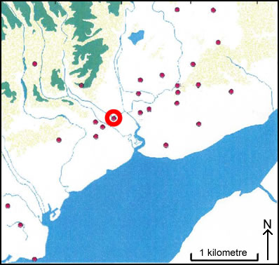
Location of the Gaer (Tredegar Camp)
SITE HISTORY AND SURVEY
The focus of this chapter will be to look in depth at one particular hillfort that is situated approximately 9.6 km from the St. Brides section of the Gwent Levels. The main concentration of the work in this chapter will be a desktop study of the site and the results of a ground survey that was carried out by the author and a number of colleagues from the University of Wales College Newport.
THE GAER - A SITE HISTORY
The Gaer/Tredegar, (ST 289 868) occupies the south-western edge of a gentle sandstone ridge at a mean height of 100m OD in a commanding position overlooking the lower reaches of the River Ebbw. The highest part of the ridge is approximately 90m. To the north the ground is fairly level, whilst to the south the ground falls gently to an OD of 30m, west and east the ground falls off much more steeply. The site can be reached easily from Junction 27 at the High Cross section of the M4 motorway. The hillfort today is nestled amongst a housing estate and if one is not aware of its presence it would remain hidden. The site is used by local people as a recreational ground for walking (Whittle 1992: 46). The hillfort would have been in a very powerful position during the Iron Age, commanding the approach between the River Usk to the east and the River Ebbw to the west.
The hillfort was once part of the lands owned by the Morgan family of Tredegar and was incorporated into the landscape of 'The Park' surrounding the Morgan family estate. Dominating the park were a series of formal avenues of oak, walnut and chestnut trees; the most prominent of these avenues was a double avenue which climbed up to The Gaer. The majority of the alterations to the grounds of the estate was undertaken in the 1790s (Freeman 1995,45).
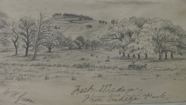
'Fort Tredegar' as seen from Tredegar Park
Drawn by WH Greene June 1892 © Newport Past
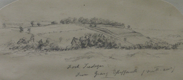
'Fort Tredegar' - The Gaer Hillfort as seen from the North East
Drawn by WH Greene June 1892 © Newport Past
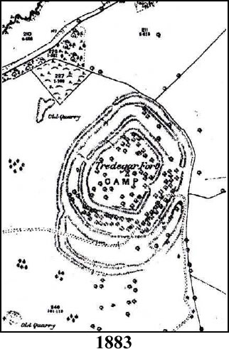
Early references to The Gaer can be found in the 1885 edition of Archaeological Cambrensis in which the descriptive account tells us that "the site is situated within a deer park and that the areas [sic] is surrounded by oak trees". The author of this article suggests that the area would, in prehistoric times, have been in amongst a primeval forest (Arch Cam 1885, 10 353-356). There may be elements of truth in this as there are traces of a submerged forest upon the Gwent Levels (Bell et al 2000, 169). In relatively recent times, other factors have noticeably affected the site. In a comparison made between the 1921 and 1937 Ordnance Survey maps and the 1883 Ordnance Survey First Edition map for this area (appendix 1), the following changes are noticeable. The First Edition map shows a central enclosure which has only one entrance on the east side, in comparison, the 1921 and 1937 maps show three entrances and the latest survey undertaken by the author, show signs of four entrances. On the southern side of the site the second rampart shows an extra entrance. On the 1921 Ordnance Survey map, a second rampart was recorded on a raised embankment south east of the site just outside of the rampart; this is not visible on the 1937 map. This is puzzling because during the survey undertaken for this project this feature is very noticeable.
Gaer Hillfort - Ordnance Survey Maps
Images reproduced with kind permission of Ordnance Survey and Ordnance Survey of Northern Ireland
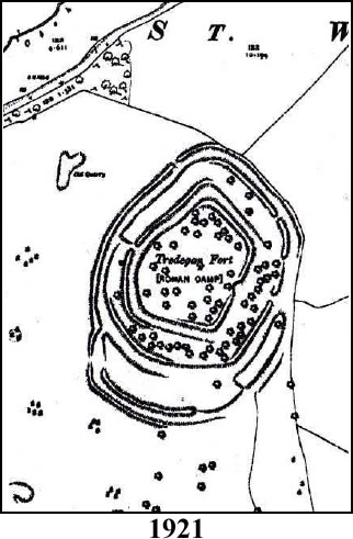
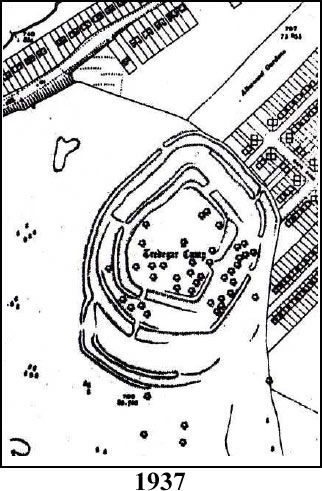
Between 1921 and 1937, a housing estate was built around the periphery of the northern side and covers a large area from the north of the site to the west. It would appear that the central enclosure of the site has not been affected by the housing estate but it is difficult to assess what damage has been done to the outer defences or if any have been lost. There are many features across the site, one of which contains masonry. Due to their exclusion from the 1937 map and with guidance from the memories of local residents, it is probable that these areas mark defence installations from the Second World War. The "Tump", thought to be a medieval motte, can probably be explained as a barrage balloon anchor base. If a mediaeval motte did exist at this site it could possibly be beneath the later features; this can only be verified through excavation.
THE SURVEY
The area of the site, approximately 5.4 hectares, was surveyed over two three-day periods, the first of which took the form of a University Wales College Newport archaeological fieldwork training exercise and was coupled with a geophysical survey of the probable W.W.II part of the site. The nature of the data achieved during the initial period required a second visit. The later visit was confounded to some extent by the unsuitability of the weather, local visitors and vegetation overgrowth. The site itself, in the care of CADW, is open to public and this access caused problems to the surveying team as station markers were removed or lost in the undergrowth. A further survey was scheduled to eliminate some anomalies that existed within the data collected on the first visit. However, to date further visits have been prevented due to weather, vegetation and the present Foot and Mouth crisis in the United Kingdom.
The survey was carried out using a Topcon GTS/212, the data from which was recorded by hand and later added to the neutral editor of Civil Cad 5.5 for processing. The final processing of data was carried out by Neil Phillips. The extensive nature of the site and its earthworks required a confusing array of survey codes to be created.
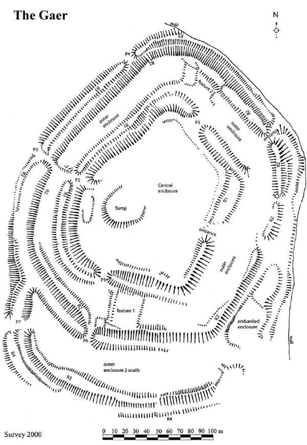
The two areas referred to as possible war defences are Features 1 and 2, though it should be noted that Feature 1 has also been described as an appended animal enclosure (Bell et al 2000, 346). The central enclosure is raised above a surrounding ditch. Outside of this ditch is an outer enclosure which is surrounded by a rampart (R2). An additional intervening rampart (Rl) exists on the western side with possible evidence of it on the south side and in a small section on the north-eastern corner. Rampart (R2) is surrounded on three sides by a ditch. The fourth side is flanked by an enclosure (see outer enclosure 2 south on appendix 2). From the north side down to the western edge and around the greater part of the south end there is another rampart (R3) and at the south end of the site there are the remnants of a fourth rampart. There appears to be two entrances; one is leading from the central enclosure on the east side, the other runs through the rampart (R2) on the north side. The other entrance ways are marked P and numbered 1-7.
Results of Survey
The results of the survey will be listed radiating from the central area outwards. Each feature will be covered along its circuit before moving out to the next band.
Central Enclosure
The central enclosure is an irregular polygon with a roughly pentagonal form. It has a long north-north-east to south-south-west axis, 150m x 100m and covers an approximate area of 2.5 hectares. The height of the enclosure above the surrounding ditch is as follows:
The height of the northern edge of the enclosure is just over 5m on a 58% slope in the west to 2.5m at 24% slope in the east. The height of the western edge of the enclosure is just over 5.6m on a 44% slope in the north to 5.5m at a 47% slope in the south. The height of the southern edge is just over 1.5m on a 13% slope in the west to 4m at a 30% in the east. The height of the eastern edge is just over 4m on a 30% slope in the south to 5m at a 13% in the north. However, the northern end of the enclosure drops onto one of the ramparts (Rl) which drops to 1.4m making an overall height of just under 2m. There are traces of inner ramparts along the north, east, and southern edges but they are not very substantial.
Entrances
PI measures 11.5 m wide at the enclosure's edge and spans the ditch which is 12m wide, this has a depth of 2.5m. The one side of the entrance passes the ground-level converged ends of Rl rampart and the central enclosure top. On the other side of the entrance, the enclosure top side stands to a height of 5m. The exact placement of the original entrance is hard to situate but what can be identified measures around 6m in width.
P2. The path of this entrance has been cut into the central enclosure edge and cuts through Rl. It is very steep and quite narrow. Measurements for this area are part of the data that has to be re-evaluated when entry is permitted back to the site.
P3. The path of this entrance is quite narrow as it cuts into the central enclosure.
The Tump
The area known as the Tump is approximately 430 sqm. This area is raised on the southern side to a maximum height of 2.3m at a 30% slope. The west and eastern sides decrease towards the north.
Ramparts
Rl appears in three separate sections. Rl east forms part of a terrace from the central enclosure. The north side edge aligns with the northern edge of the central enclosure; the depth of the ditch on that face does not decrease. Rl northwest rises from the northern outer enclosure and continues around the western face of the central enclosure creating a slight inner ditch ranging from 2m to 8m. The outer face of the rampart is higher than the western outer enclosure and ranges from Om in the north to 9m in the south. The southern end of the rampart is cut through by P2. The southern section has an inner ditch depth averaging 5m with an outer height range of 1.5m to 6m.
The outer enclosure incorporates the inner defensive ditches and the outer rampart, although on the western side, the area is flat. The western edge differs in its appearance; it is somewhat narrower than the other ramparts and slopes. The slope appears to be a natural gradient of the ridge. The outer eastern edge is also different as there are no traces of a ditch between the central enclosure and the outer enclosure. In the north and south section of the outer enclosure are Features 1 and 2. Due to their shape and their absence from the older Ordnance Survey Maps, both have been designated as being used during W.W.II. Although the shape of Feature 1 in the southern section of the outer enclosure, adjacent to P3 and P6, may suggest possible agricultural enclosures.
R2 forms an almost continuous rampart around the whole site. In some parts R2 has inner as well as outer banks. On the southern side of the entrance the rampart stands 1.6m above the outer enclosure with a 24% slope reducing over a length of 43m to 4m. The outer height of the entrance is 5m on a 48% slope reducing to 2m at the end of the rampart. The next section has lost most of its inner bank but stands at an average of 8m above the surrounding ditch. The southern end, which is 30m long, has what appears to be another entrance which is very eroded. R2 from this point loses the inner bank, although a very slight rise is visible in places. This feature measures approximately 195m from end to end. The outer bank drops from 3m to 4m at the southern corner. The slope gradient at the corner is 63%. As the rampart reaches 14 P6, the height reduces to 3.5m and the slope reduces to 45%. West of P6, the inner bank R2 is picked up again and continues from 2m for approximately 85m. The outer bank of this rampart averages 5.4 m at a 45% slope gradient along the 160m length. The last section of this rampart continues for 260m from the entrance of P2. The western section measures 145m but shows no traces of an inner bank. The outer bank is located from the path P5/P2 and reaches a height of 3.9m with a 34% slope gradient. At the northern extremities of this rampart the outer banks reach a height of 6.8m with a 62% slope gradient. At Feature Two, one can identify three cross-terraces that have been cut into the bank, and the inner bank of R2 can be clearly identified. The inner bank climbs in terraced stages from 2m - 1.3m - 3.2m. The outer bank of R2 runs along the north eastern section to the entrance. The measurements vary from 7.4m at a 65% slope gradient to 5.5m at the entrance.
R3 runs between the wall along the east and northern sections and is opposite R2 but is only recognisable as a rampart in the extreme north where it moves away from the wall. At this point the inner height of this rampart is 3.5m whilst the outer height is 6m above a natural slope. R3 is crossed by the entrance of P4 at a distance of 45m south from the wall, the height above the ditch at this point is negligible. R3 continues for a further 110m where it is met by the entrance P5. This section of the rampart has an inner height averaging 4m and an outside bank that averages 2.5m. The next section of R3 measures 150m in some places losing both its outer or inner slopes. The highest point is north of P7, opposite the west side of outer Enclosure Two. Here the inner height is 1.6m and the outer height is 3.6m. The last section of R3 incorporates the entire south side of the second outer enclosure. This section has a length of 210m with a maximum inner height of no more than 5m and a maximum outside height of 3m.
R4 is only visible as a 50m section of a rampart in the extreme southwest of the site. Its maximum inner height measures 8m and its maximum outer height is 1.5m.
Enclosure
The final section to be recorded is an embanked enclosure on the eastern side of the site. This feature has two terraces and was covered in old growth trees which made surveying difficult. 15 The feature has a long north south axis of 62m and slopes gently to the south by 3m. At the widest part there is a 24m length tapering to nothing in the north. The height of this feature above the surrounding terrain varies from 1.8m to an average of about 8m. The southern end is badly eroded and becomes indistinct as it converges with R3.
Interpretation
The area labelled Tump has been dismissed as being part of W.W.II defence structures. However, care must be taken here for although we know that the area was used in some form during the Second World War, documentation for this has proved impossible to locate. We have no way of verifying whether the concrete slab that is still in situ was placed upon some other form of structure, this can only be confirmed or dismissed through excavation. Features 1 and 2 were similarly dismissed, due to their absence from the Ordnance Survey Maps prior to 1937 and their visible and physical appearance. The main enclosure shows the possible existence of a rampart along the south eastern section. The same evidence recorded in the east and north seems less conclusive and may be the results of quarrying. The eastern entrance seems to be original and opens onto the largest part of the outer enclosure area. The other three entrances PI, P2, and P3 are all later additions and are perhaps responsible for the alteration of the ramparts and ditches.
The surrounding rampart, R2, is perfectly adapted to the natural hillside. On the western edge there was no need to create inner ditches as the natural slope of the hill required only the raising of ramparts. In the south and north where the land is flatter, both ramparts and ditches were used. The eastern side is difficult to interpret as this has become the main means of access to the site from the housing estate. Also, the huge amount of trees that were planted around this site have caused a great deal of damage. It has been suggested that the eastern side of the site was the original entrance, but as the entrance to the inner enclosure is situated here it is unlikely that the outer enclosure would have had an entrance way as well. To do so would have made access too easy to the inner enclosure for unfriendly visitors. It is more likely that the main entrance to the outer enclosure was situated to the north where the most impressive ramparts now stand. Access from this direction would have been along the top of the ridge, whereas from other directions, the passage would have been uphill, through dense 16 forest and marshland. In every day use this would, therefore, make the first option the most favourable approach. The extensive nature of the ramparts that survive here only show how much effort was given to defending this side of the hill fort.
The embanked enclosure is difficult to interpret, it is possible that it formed part of a defensive structure that guarded the outer enclosure. The damage to the outer enclosure is too extensive to be more conclusive. It would seem that the hillfort had one entrance through each ring of the defences. Later remodelling of the site by landscaping and other factors have caused serious damage. The alteration of the ramparts has created a lot of confusion over the authenticity and origins of many of the features. The northern rampart is perhaps a very good example of the original nature of the site. It is probable that the other ramparts would have been of the same magnitude. If this was the case then the defences at this site would have been spectacular, giving excellent panoramic views in every direction. The most unfortunate outcome of the survey was that there are no visible traces of any settlement structures remaining at the site. Feature 1 is very ephemeral in nature and it has been described as an appended animal enclosure or the remains of activity during World War Two. The true nature of this feature can only be substantiated through excavation. Lack of structural evidence may be due to alterations that have taken place here for centuries or indeed, through hundreds of years of climatic change. What appears, at first glance, to be a well preserved monument is in fact one that is in a very poor state of preservation. Below is a list of the many things that may be responsible for the visible changes at the site.
- Landscaping of the monument and its surrounding area in the 18th century
- The use of the site during W.W.II.
- The central enclosure used as a golf course.
- The use of the ramparts as a scrambling track in the 1970s.
- The site is used by both children and other members of the public as a recreational ground.
The survey has shown that there was a need to clarify and record evidence that had been overlooked at the site. The problems during the survey itself show that there is a definite need to revisit the site in order to make a more intensive study. The survey has clarified that 17 much evidence has been overlooked at this site and that excavation is required here if we are to enhance our meagre knowledge of Welsh hillforts.