Newport Past

Did Newport have a Town Wall?

© Bob Trett July 2010

Historians have never agreed whether or not Newport had a town wall.  A fuller account of Newport from John Leland’s ‘Itinerary in Wales’ mentioned above recorded that:

Newport is a bigge towne wherof that parte where the paroche chirch is, stondith on a hille. The chirch is S. Guntle (Woolos), Olave in Englisch.
Ther is a great stone gate by the bridge at the este ende of the toun, a nother yn the middle of the town as in the High strete to passe thorough, and the third at the west end of the toune : and hard without it is the paroche chirch.  The fairest of the toun is al yn one streate. The toun is yn ruine.  Ther was a house of religion by the key beneth the bridg.  The castelle is on the este side of the toun above the bridge.

Later in the same account he said:

Newport is in Wentlugh (Gwynllŵg) a myle and more by foote path from Cairlion, and standeth on (the river) Uske, having a prety stronge town; but I marked not whyther yt were waulled or no. [1]

No other visitor to Newport has recorded seeing a town wall either, although many have claimed there was one there once. For example in 1801William Coxe claimed:

Newport was once surrounded by walls, though no vestiges at present remain. [2]

However the Newport historian James Matthews stated that:

That extravagant and unwarrantable statement: “Walls of considerable strength surrounded Newport (!) in the palmy days of the Castle” ought to be dismissed from the mind of every intelligent person, as there is not an atom of evidence that can be brought forward in support of such a recital   [3]

Since then most historians have been circumspect on the issue, although the presence of gates into the town has never been challenged.

One of the gates mentioned by Leland is the East Gate by the bridge.  (7 on the conjectural view of Medieval Newport) An engraving of Newport Castle published in 1732, by Samuel and Nathaniel Buck, shows a stone gate with a pointed arch across the west end of a wooden bridge.

William Coxe recorded that:

The pivots belonging to the hinges of the east gate, near the bridge, are discernible in the walls. [4]

The West Gate is still commemorated by the Westgate Hotel building and it would have crossed the road between High Street and Stow Hill. Commercial Street was not constructed until the nineteenth century.  A previous gate may have been nearer to Skinner Street, because a restriction in the width of High Street just at the junction with Skinner Street can be seen on early maps of the town.  This first gate may be one mentioned in a deed of 1444 which refers to:

A tenement in the small bailey near the gate of the aforesaid town, where the hundred house was built above.  [5]
               
The second gate, which contained a gaol, but presumably no longer the Hundred House, is probably fifteenth century and could have been built soon after 1476. A charter of that year gave the burgesses the right to build a gaol within the town. [6]  This gate was demolished in 1799.  It was replaced with a hotel, and this in turn was replaced by the present building in 1884. The proprietor of the Westgate Hotel at that time was Mr Samuel Dean.  He recorded that:

In excavating underneath the old (former) Westgate Hotel, preparing the foundations of the present building, the workmen came across an old spiral stairway, and at the bottom a stone porch, forming the entrance into a subterraneous passage or subway, was discovered, leading under the road (Stow Hill). [7]

In the 1570 survey of rents in Newport owed to the Earl of Pembroke, there is a reference to ‘Crooks Gate’. [8] This appears to be the West Gate, and probably refers to the gaol in the gate.  In 1801 William Coxe referred to the West Gate as having been used as the town prison, and that it had lately been taken down. He called it an ancient structure in the gothic style, built of red grit stone, with a shield charged with a chevron on each side.   The shield was probably from the coat of arms of the earls of Stafford, later dukes of Buckingham, and lords of Newport from 1347 until 1521.

The location of the Middle Gate cannot be identified from Coxe’s account, and it has been suggested that it stood in the middle of the High Street. (4 on the conjectural view of Medieval Newport) The 1884 Ordnance Survey map identifies it as being close to the Murenger House. However a logical position would have been in Thomas Street. This street used to go from alongside the old Post Office building in High Street, opposite the Kings Head Hotel, providing access to the mill and to the north of the town.

In addition to these three gates there appear to have been other gates.  Newport Castle had both a north and south gate in its curtain wall, and there are records of a Paynes Gate, which gave access to Baneswell and a gate between the Austin Friars and the town wharf. Of course these gates may not have been defensive structures, and James Matthews even refers to the old West Gate as a toll booth.

There is also the present public house called the Murenger House, at 53 High Street. It has been claimed by tradition that it belonged to the Murenger (an official responsible for town walls and for collecting money for their maintenance in the Middle Ages).  In fact the Murenger House has a mainly modern timber framed frontage, with three upper stories under the gable.  The first floor front room has a plasterwork ceiling decorated with a Tudor roses and floral pinecone finials. It appears to be Tudor, or, according to John Newman, early 17th century in date, [9] and therefore after any town wall would have been in use. However the thickness of the side and rear wall may indicate these were built of stone, and they could be considerably older than the frontage .The building is only referred to in local directories as ‘The Murenger House’ after 1880.

There are earlier references to another Murenger House, with a shield and arms carved over the front door.  In 1801 William Coxe refers to the Murenger’s House as being ‘an old spacious building, with an ornamented front, and a coat of arms, carved in stone, over the door’, and it appears this building was demolished in 1816. It stood on the corner of High Street and the modern Bridge Street, on the site now occupied by the NatWest Bank. In 1750 it was referred to as ‘The Great House’ and in 1553 was the house of George ap Morgan and was described as ‘the strongest place in all the town’. [10]

There is at least some limited documentary evidence to suggest that Newport had town walls.  A 12th century charter by William, earl of Gloucester, refers to granting the Priory of Goldcliff property ‘outside the walls in Newport’. [11]   A deed dated 1433 exists in which Humphrey, earl of Stafford, granted John of Newport the right to erect and maintain a tenement ‘situated on the walls of the town adjacent to Gervey’s Gowte’.  The origin of ‘Gervey’ is probably the personal name Gervais, but ‘Gowte’ means gate, often associated with sluice gates used in drainage. [12]  This is little to go on, but there are many references to the Great Bailey and the Small Bailey of the town. The term ‘bailey’ usually refers to the area inside the circuit walls of a castle or town. In the case of Newport these baileys contain most of the town burgage plots, which in the 1570 survey were still paying rents to the lord.

As mentioned earlier the Great Bailey covered the area from the castle to the town pill, and included most of High Street. The Small Bailey included an area from the West Gate to the river downstream from the town pill, but excluding the site of the Austin Friars. The properties on Stow Hill and Mill Street would also have been outside the town baileys. 

There is one clear record that shows that the Great Bailey had a wall.  In 1444 John Seyntey sold various properties in Newport to Thomas Leny. These properties included:

A tenement ... in the great bailey in length along the highway at the front and up to the wall of the aforesaid bailey at the back ... 
Seven unbuilt tenements, five of which lie together in the great bailey on the south side of the highway of the aforesaid town at the front, up to the wall of the aforesaid bailey at the back.  [13]

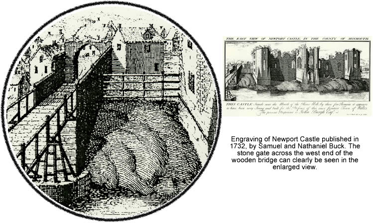
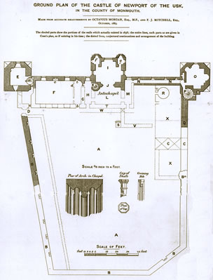
Newport Castle also had a curtain wall that once stood behind the surviving frontage.  This was noted by William Coxe and a small part of the castle’s north curtain wall was standing until 1970 when it was removed during road widening. In 1885 the antiquarian Octavius Morgan produced a plan of the castle. The ward within the curtain wall was sub-rectangular. The south curtain wall was at a right angle to the main castle range alongside the river, but the north curtain wall was at an odd angle, slanting slightly to the south.

From looking at a map called the ‘Trigonometrical Survey of Newport’, which was published in the1850s, [14] it is possible to line up the north curtain wall of the castle with old property boundaries, now mostly gone. These property boundaries continued to the rear of premises facing on to the west side of High Street.

It is known that the west side of the moat of the castle and some nearby properties were destroyed during the building of the Monmouthshire Canal in 1792. However there are surviving property boundaries on the far side of the canal, but on the same line as the north curtain wall of the castle. They crossed Thomas Street where this street is shown as widening out.

The point where Thomas Street widens out is a likely position for a Middle Gate, set in a town wall. (see plan) In 1907 there is an account of early walls being discovered during the construction of the Savoy Hotel next to Thomas Street.  It is possible that these walls could be connected with the town wall or the East Gate. [15]  This would mean that part of the town wall would have been re-utilised as the north curtain wall of the castle. The present stone castle is thought to have been built and altered in the thirteenth or fourteenth and in the fifteenth century – so a town wall would have been there already.  If the castle north curtain wall was originally part of the town wall this would certainly explain the odd angle.

With a few gaps, a line of property boundaries associated with the possible wall continued west from the castle north curtain wall, then curved around the back of High Street and continued to the vicinity of the West Gate.  To the east of the West Gate, by the junction with Skinner Street, these property boundaries continued in a curve towards the river. Near the river the boundaries were again obliterated by the construction of the Monmouthshire Canal at the end of the eighteenth century.

This line of property boundaries finished close to where it is now thought that there was an old pill or inlet (on the site of the present Riverfront Theatre) running into the River Usk. This inlet contained the medieval ship that was excavated in 2002. The inlet could be associated with a medieval town wall or defences, and with the former Austin Friars lying just outside.

However another clear line of property boundaries continued beyond the West Gate, up Stow Hill, along the edge of a sloping ridge of land containing former burgage plots.. This line of property boundaries finished close to the church of St Woolos.  It seems likely that an earlier defensive ditch existed, before any town wall was built. In the eighteenth century a ditch still survived. It was known as the Town Ditch, and ran from the top of Stow Hill, and then possibly curved to join on to the line of a medieval town wall near Baneswell. [16]

Part of a town ditch running between the Westgate and Newport Castle could also have been replaced by a stone wall, with another section of wall running from the West Gate to the river. A survey of 1570 refers to ‘Hirstingeste Ditch’ in the area of Baneswell, and this could be a reference to the Town Ditch still existing on Stow Hill after the building of a town wall that protected the smaller area. Alternatively it could relate to the Town Pill. [17]

There is much more that could be said for or against there being a town wall around Newport.  One criticism is that it would appear that no physical evidence of a strong stone defensive wall has ever been discovered.  However only a handful of medieval objects have been discovered from the whole of Newport – at least until the Newport Ship was excavated. In Newport Museum the few medieval finds from the town include a small quantity of late medieval or Tudor pottery from Newport Castle, some fourteenth century pottery from the National Provincial Bank (now NatWest) opposite the Westgate Hotel, and the Tudor and later pottery from the Murenger House at 53 High Street.  There are also two medieval tiles from St Woolos Church (outside the medieval borough) and part of a 15th century stone cross found in the river near the Town Bridge.  With the nineteenth and twentieth century expansion of Newport little was saved, and most of the medieval town was obliterated without record.

Another possible clue to the existence of a town wall is that in 1447-1448 the north curtain wall of the castle was raised by 3 feet. [18]   It is interesting to speculate whether this was the old town wall being improved in order to match the rest of the curtain wall of the castle. The west and south wall would have been newer in date and purpose built for the castle. More possible evidence for a town wall can be seen in the cellars of High Street. (Follow this link)


1. Toulmin Smith, L. (1906).   45

2. Coxe, W. (1801).   48

3. Mathews, J. (1910).   94

4. Coxe, W.  (1801).   48

5. National Library of Wales Tredegar Papers  62/29

6. Rees, W.  (1951).     53

7. Matthews, W. (1910).   108.   Also The Monmouthshire Merlin  July 11 1884

8. Bradney, J.A.  (1993)      33

9. Newman, J.    ‘Buildings in the Landscape’  in Griffiths, R.A. ( general editor)  The Gwent County History Volume 3. The Making of Monmouthshire, 1536-1780.  (Cardiff 2009).  347

10. For a fuller description see my article The Two Murenger Houses of Newport  in Gwent Local History. Number 106 (2009) pages 20 - 31

11. Patterson, R.B. (1973).   Charter  no 280 (93a)

12. Gwent Record Office  D.43.5458

13. National Library of Wales Tredegar Papers 62/29.  It is curious that the five tenements were on the south side of the highway, since if they had the wall of the Great Bailey at the back they should be on the north of west side of the Bailey. Possibly this is a mistake in the deed or the translation or possibly the bailey wall formed a circuit. This reference was pointed out to me by Tony Hopkins

14. Newport Museum and Art Gallery (no reference number)

15. Information from Haydn Davis referring to an article in the South Wales Argus in 1907

16. Jones, B.P.      From Elizabeth I to Victoria.  Newport Monmouthshire 1550 – 1850.  (Newport 1957).  63.   The eighteenth century ordinances of the Borough of Newport refer to the Town Ditch running from near the Church to Baneswell.

17. Bradney,  J.A.  (1993).   33

18. Pugh, T.B., (1963). 233

© Bob Trett 2010